InverseLite supports the analysis, demonstration and interpretation of single-point analysis data to select resistivity columns for geophysical exploration. The latest version of InverseLite 5 supports Wenner and Schlumberger polar systems, and it also integrates fast data entry with Spreadsheet Data Editor Interactive.
Currently, most use analysis software that performs multi-point processing, users need to specify a subset of similar soundings for an analysis. Subsets can be glands or area arrays. Then select a point with a typical apparent curve, analyze the single point, then assign the resulting model to the rest of the set, and then analyze the multipoint.
Main features of InverseLite software
1. Inverse multipolar electroimaging method data of the Wenner and Schlumberger polar system.
The program has the main function of interpreting the Wenner and Schlumberger electrode system multipolar imaging method dataset. The software can also be used to generate apparent resistance values for any resistance data layer. Users can easily use InverseLite 5 to interpret depth measurement data on any terrain, for borehole location, platform engineering research, and underground mineral exploration.
2. No need to predict or launch models
This is a major advantage when starting to probe the apparent electric field.
3. Detailed error checking of inverse models
If errors occur in inverse models, the software displays a message that allows users to quickly proofread and fix problems.
4. Apparent resistance distribution data redirection
Users can easily redirect the apparent resistance distribution data through this software with only operations in the main interface.
5. Support multimedia entertainment system and resources on Windows.
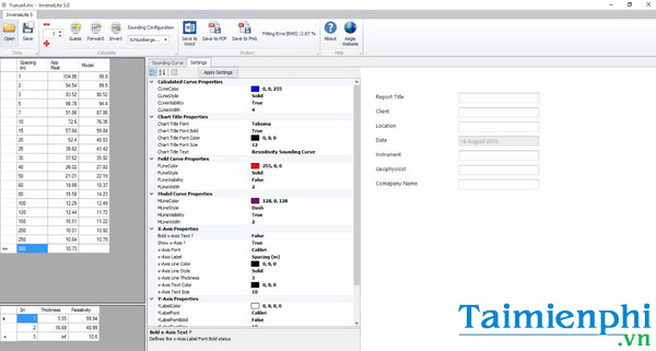
Users can export reports analyzing and processing current data in the form of MS Word files and PNG image files.
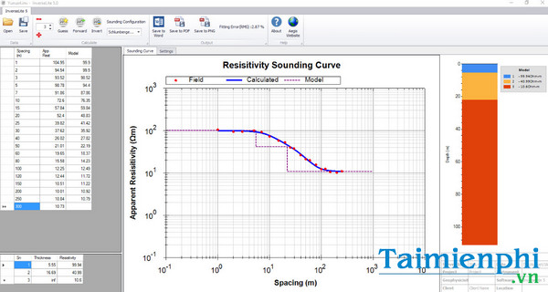
6. Display as graphic magnetic field data and opposite current
When using the software, users can redirect data models, automatically reverse shapes, automatically predict sample models, data layers UI design. The advantage of InverseLite software is that it increases the ability to analyze and interpret geophysical measurement data better for geologists.
The most commonly used method of interpretation is to match apparent curves that are prone to errors and have few ways to check correctness. However, thanks to InverseLite, geologists can easily calculate and check the initial data as well as the difference in scale.
Some software supports single-point (1-D) analysis on Windows computers such as AGI EarthImager 1D For VES.
If you are a person who often has to perform analysis, topographic measurements, or probe different locations, InverseLite 5 will really be the best companion for you with a system that supports the analysis, demonstration and interpretation of single-point analysis data for geophysical exploration.